
Do you recall the times when being lost on the road used to happen frequently?
However, modern GPS navigation systems have made it simple for vehicles to travel across towns or challenging terrains without getting lost while driving.
Yet, with these affirmations on GPS (Global Positioning System), the question needs to be asked. When was GPS invented? How did it evolve with time to make human traveling effortless?
History of GPS

How far automotive navigation has evolved in the previous 40 years is simply amazing. Car navigation has undergone numerous adjustments, all of which have been made to enhance its accuracy and added utilities.
You might be surprised that its roots go back to the 1930s, decades before satellite navigation systems were utilized to direct drivers to their destinations. Now that drivers can navigate through GPS on smartphone apps and in-car systems, the need for foldable paper maps has reached a standstill.
Before roadways and highways were built, getting lost was a common reality as they were still just ideas on blueprints. So, the importance of digital maps for vehicles was quickly identified. What began as folded maps stuffed in the coat pocket grew into a billion-dollar business.
To understand in a broader perspective, the car navigation system dates from the early 1930s to today’s AI tech map directions.
Let’s study the components of early car navigation systems.
Early Methods For GPS Navigations For Cars
Here are some early attempts made by big brains of the world to create easy and reliable car navigation systems.
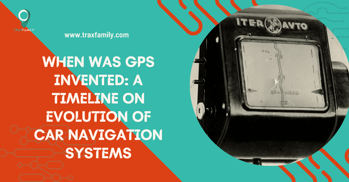
1. World’s First Automobile Navigation System in 1930: Iter Avto
Made in 1930, Iter Avto worked with a simple formula by the Soviet Union first. It had a circular slider chart that showed directions, travel times, and the separations between cities and towns.
The scroll rate was managed by a cable attached to the speedometer. Moreover, the display moved in a manner that was proportionate to the vehicle’s speed.
The Iter Avto had flaws, though. It did not take into account detours or alterations in road conditions. Moreover, it was only accurate for predetermined routes.
2. World’s First Widely Accessible Car GPS by Honda in 1981: Electro Gyro-Cator
First introduced in Japan in 1981, a compact superfluid helium gyroscope was employed in this “inertial navigation system.” It was more akin to the mechanisms used by military pilots during the Cold War.
It was helpful for long-distance travel because it guided drivers more precisely in organizing their routes and predicting their travel time.
The Electro Gyro-Cator cost $2,500, which was way expensive. It was 25% of the automobile’s cost, making them inaccessible to many.
3. From Paper to Digitalization in 1985: Etak GPS System
In 1985, an alternative system named Etak was the first to replace paper maps with electronic versions stored on physical media in the US. Each tape covered a portion of a city when the device read mapping information from a cassette drive.
Etak also had a monochrome display that flickered as the automobile traveled and used dead reckoning rather than GPS to navigate.
The Etak Navigator did, however, have some shortcomings. Due to its high cost ($2,800), many drivers could not afford it.
4. First Coloured Car GPS: CD-ROM Navigation System
Japan contributed less well-known but significant advancements in navigation systems to the car sector in 1987. It incorporated the use of CR-ROM in its latest Toyota Crown for text.
It’s due to the digital maps that were stored on CD-ROMs. Drivers could view their whereabouts and route on the screen itself. All in all, drivers could easily recognize the maps for highways and terrains due to the usage of colored displays.
Yet, there were issues with the Toyota CD-ROM navigation system. It cost $2,000, which made it pricey. Additionally, it lacked specifications such as voice activation and real-time traffic, making it inadequate for drivers.
5. First Automatic GPS System: Mazda Eunos Cosmo
Mazda unveiled the first-ever automated GPS for built-in car navigation in 1990.
Only offered on Japan’s gadget-obsessed Eunos Cosmos models, Mazda’s navigation system was integrated into the vehicle itself. Your location on the road could be realigned instantaneously from satellites in orbit for the first time in history.
Above all, this navigation system remarked the beginning of the so-called ‘space age’ by using satellites for the car GPS.
6. GPS System With Cartridges: GuideStar
One of the earliest in-car navigation systems that employ GPS technology was the GuideStar GPS, unveiled by General Motors in 1995. Additionally, it enabled motorists to look up attractions like restaurants and petrol stations along their route.
It was first made available in Florida on vehicles from Avis Rent-A-Car in 1992 under the name ONIS. During the 1995 model year, the system was formally offered to Oldsmobile 88’s range of cars as a standard option.
Its new name, GuideStar, is used for retail sales. Only California and Las Vegas were first mapped, but further mapping for larger areas was accessible too.
7. First Touch-Screen GPS Display: Alpine CVA-1005
This GPS satellite-based flip CD-ROM drive system was introduced first in 1997 by the Japanese estate Alpine. The initial device had a touch-screen display and employed GPS technology to give drivers up-to-the-second location and navigational information.
These CDs covered only a few states due to their limitation on transferring route data.
Drivers could view their itinerary due to its capacity to retain and show digital maps. Yet retrofitting was possible with this system so that any car buyer may equip their vehicle with GPS.
8. First Portable GPS System: StreetPilot
The first transportable StreetPilot GPS navigation system for use in cars was released by Garmin in 1998. It utilized cassettes with mapping and featured a monochrome screen. A relatively limited area could be covered by one cartridge.
StreetPilot represented a significant development in automobile navigation technology by giving drivers a user-friendly tool that could be used in different vehicles. Drivers may view their route while driving, owing to its capacity to preserve and show digital maps.
The StreetPilot system even had issues, such as a short battery lifespan and the requirement for manual map updates.
Above all, the use of the built-in GPS was declining by 2000 as smartphones advanced exponentially.
Advanced Methods For GPS Navigation in Cars
With the advancement of technology in the 21st century, tracking and locating a destination, person, and locating car has become easy.
Note: Google Maps is the navigation software that helps to track locations with advancing technologies.
Google Maps For Car Navigation System

Google Maps is a robust mapping and navigational tool created by Google. The program, first released in 2005, has undergone countless updates and enhancements to become one of the most popular navigational tools on the market.
360° panorama, seamless navigation, geographical searching, real-time traffic, and trip planning for biking, driving, walking, or taking public transportation are some of these capabilities. As a result, it has altered how early car GPS systems were seen.
However, some features that differentiate it from the early GPS navigation system for cars are:
- Saving locations of maps with or without an internet connection.
- Real-time panoramic view of the street to visit a place or location while surfing through mobile from anywhere.
- Receive detailed driving instructions and directions for using public transit for walking.
- One can escape traffic congestion and get to a location quickly with the help of its live traffic updates feature.
- Share your whereabouts with others, or use the straightforward map-sharing function to locate family and friends across the globe.
End Remarks: Future of Car GPS Navigation System
Together with voice commands, real-time traffic reports, and even virtual reality overlays, GPS technology has evolved substantially in recent years.
However, researchers are looking into alternative car navigation technologies, namely using billion data points for greater accuracy and sensor sources to deliver precise location data.
Frequently Asked Questions
A GPS receiver determines its exact location using the data it gathers after receiving signals from a system of satellites.
Yes, a GPS can function without internet connectivity, operating on signal transmission with satellites rather than internet connections.
The accuracy of GPS is limited in locations where satellite signals are blocked, and it requires frequent updates to maintain accuracy.
With technological progress, GPS technology now offers more sophisticated functions like speech navigation, timely traffic updates, and compatibility with gadgets like mobiles and in-car entertainment systems.
A car GPS module can cost between $50 for a simple model and a few hundred dollars for top-of-the-line features.
The global positioning system (GPS) was first invented in 1973 by the United States Department of Defense.

Meet Klark Kurz, a GPS enthusiast and author with a B.B.A. in Finance from Texas A&M University. With a passion for technology and innovation, Klark provides accessible and user-friendly content to help individuals and businesses make informed decisions. As a regular contributor to TraxFamily.com, Klark’s insights and practical advice make GPS tracking more accessible, affordable, and user-friendly.